Today's intention was for the first longish hike in the U.S. during this trip. A loop around Devil's Garden inside the Arches National Park. Some 12km, which is not that long but longer than we have walked in during our week here.
But it was not to be. So, what happened? Wind happened. Strong winds. Strong winds which brought back memories of Hans' first day on Camino de Santiago across the Pyrenees. The wind was strong enough to physically shift you and here you are walking on ridges. With steep drops on either side.
The day started off well enough. The rain forecasted for overnight seemed to be gone. Not even the ground was wet as we woke up although it was overcast.
At 7.30am, we arrived at Arches National Park. You see the park entrance down there in the photo.

We continued through the park to the Devils Garden Trailhead and began our hike there before 8am.
Looking back almost immediately after commencing the hike and we saw this. Sand blown into this crevice. Lots of it. Hmm... I wonder what that meant. Well, it became obvious soon enough.

The major visual attraction in Devil's Garden is Landscape Arch where it looks like the below. The background, people.

Landscape Arch is amazing to look at as your imagination runs wild trying to figure it all out.
This board told the history including the latest drop of stone from the Arch back in 1991. The recommendation is that if you hear "cracking and popping noises" run as fast as you can away from any rock feature. No kidding!

One more photo of Landscape Arch. Fantastic.

At his point we should mention that it was windy, damn windy. And sand was blowing with it. Not pleasant and we chewed on a lot of grit.
Heading to Landscape Arch the trail had been flat and well formed. That now changed to ascending rock and ridge walking. It was all too much for Di who decided to return to the trailhead at this time. Hans decided to continue as the wind continued to pick up.

Alpine country, ascension, a windy day. It can only mean one thing. More and more wind.
Hans intended to walk to Double O Arch on the loop but the trail was deserted. Hmmm. He walked as far as up to the ridge that you can see before calling it quits. It did not come across in the photo but there were gail force winds up there. Gusts to 90km per hour and walking along quite a narrow rock ridge. With some distance down on either side. The wind physically moved Hans and to continue would have been madness. So he aborted his hiking mission here but he was disappointed.

Hans decided to check out a couple of other arches on the way back. First, Navajo Arch. You can walk underneath this arch and even have a break there. Which Hans did as it was less windy. He had the thermos so enjoyed a cup of hot tea (none for Di!)


He then headed to Pine Tree Arch and found it was sandstorm conditions. The camera was not happy and we think here it got more sand that it bargained for. It misbehaved for the rest of the day.


In the meantime Di had contemplated the Park Avenue hike but the sandstorm there was also ridiculous. Here is photo evidence from about 20 seconds outside the car.

She then decided to re-hike The Windows primitive trail as it appeared more sheltered. It was and it was a nice hike of a few kms.
Meeting up we decided to do another hike in a State Park some distance away. A hike described as "easy" and where there would be little or no sand.
The second hike for the day was a rim walk within Dead Horse Point State Park. Post the interrupted hiking at Devil's Garden, we both felt that we needed to add something else.
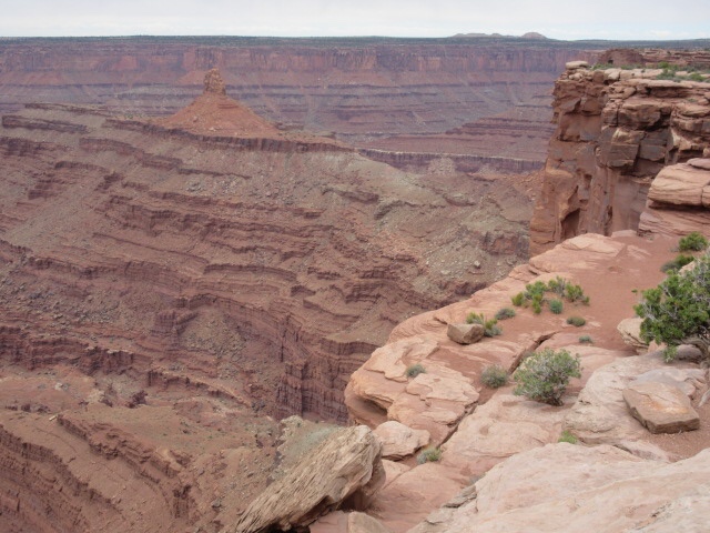
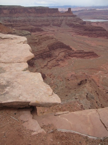
Dead Horse Point State Park is towering some 2,000 feet above the Colorado River (at a total altitude of about 1800m) and provides a panorama of the nearby Canyonlands National Park's sculptured canyons (obviously), pinnacles and buttes.

By the way, can you believe it? During National Park Week when access to all national parks is free, we chose to visit a State Park. No, State Parks are not National Parks and entry fee here was $10. But worth it.
At Dead Horse Point State Park, you can string together 2 different shorter rim trails to create something longer. So that's what we did. We hiked East Rim Trail to the Visitor's Centre, then across to the western side and then West Rim Trail back to Dead Horse Point Lookout. Sort of like a triangle.
At Dead Horse Point Lookout, you have fantastic views over Colorado River.
Neither of us would not step out there...
We were not quite sure what these things were. We found out later they were potash ponds. Potash is salts and potassium used in fertilisers. You learn something new every day.

Just before you get to Dead Horse Point Lookout, you need to cross something that is simply called the "Neck". This is the Neck and it is narrow. Just enough for 2 car lanes and a walking track.

Well, it was a harsh weather day and it wasn't over yet. The temperature was low and it was dropping further. And then... Snowflakes. You may be able to see snowflakes against the green to the left in the picture below.

We just couldn't believe it. Gale winds, sand storms and now snow. Not much and not for long but still...
We popped into the Visitors Centre to buy a cup of hot chocolate and eat our homemade bread roll. They had a whiteboard with park information and there you had it. All the signs of foul weather.

What do you do in cold harsh weather...shop! And we found a really nice t-shirt for Hans.
All rugged up and still happy as Larry we stepped out again. Just awesome views and landscape. Hans is pointing back to the point we walked from.

Colorado River again but now from the West Rim a bit further north.

Given the Neck's narrowness, the rim trails were next to the road. And if you didn't know where you were, you could always read the sign.

It turned out that the length of our Rim Trail at 7.6km was longer than Hans' Devil's Garden hike of 7.2km. Still, the two of them together added up to almost 15km of hiking today so that was at least something.
It was nearing 4pm and we had enough of the cold weather. We drove back to our motel and hoped for warmer weather tomorrow. The warm shower was fantastic...
We couldn't get excited about dinner so we walked across the car park at our hotel to the nearby Denny's. Just fine.
Footnote:
You may wonder about the Dead Horse name. Unfortunately it's not a pretty story.
Well, Utah State Parks describes it as follows:
"According to one legend, cowboys in the 1800s used the point as a corral for wild mustangs. The cowboys rounded up the herd, pushed them across the 30-yard-wide neck of land and fenced the neck with tree branches and shrubs. Some of these horses were left corralled on the waterless point, where they died of thirst 2,000 feet above the Colorado River. Although wild horses no longer roam the mesa top, the area's local name was kept when the park was established in 1959".
Whatever the truth was, this story is as good as the next.
No comments:
Post a Comment